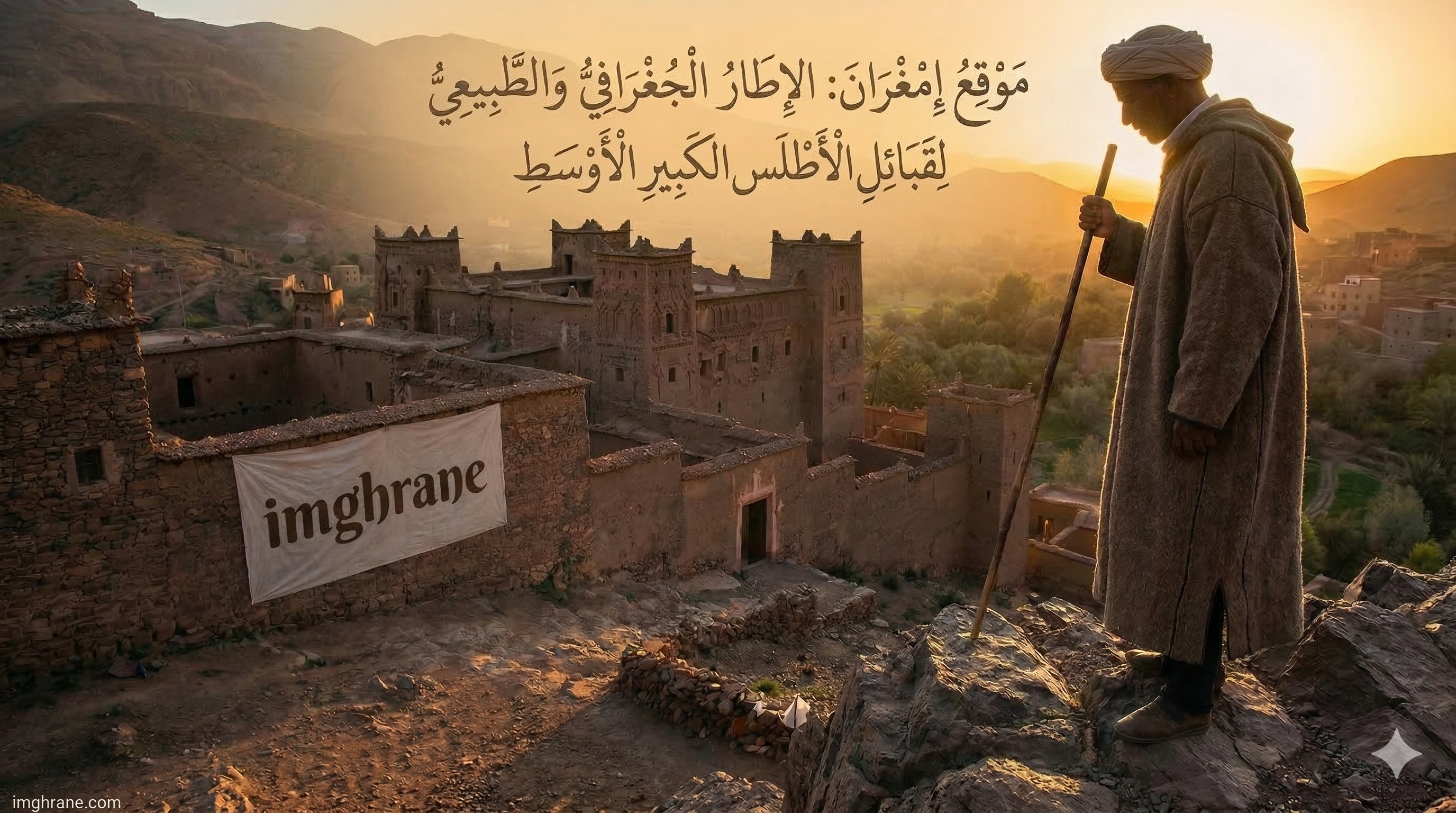
Location of Imghrane: The Geographic and Natural Setting of the Central High Atlas
A detailed study of the geographic location of Imghrane within the Central High Atlas mountain range, the region’s terrain, and its strategic importance as a trade corridor between interior and Saharan regions
Location of Imghrane: The Geographic and Natural Setting of the Central High Atlas
Published: March 12, 2026
🗺️ Introduction
The geographic setting forms the material foundation of a population’s life. Examining the natural framework inhabited by the Imghrane tribes will help us understand certain events in the region’s history and the bonds connecting its constituent groups.
Although defining the geographic domain is a critically important element in monographic studies — as it frames the study in its spatial dimension and temporal context — this process is not always straightforward, especially when it comes to the tight link between time and space, where territorial boundaries shift in tandem with historical periods.
🏔️ The High Atlas Mountain Range
The High Atlas mountain range is the largest mountain chain in North Africa. It extends across southern Morocco between latitudes 31° and 33° North, stretching 700 km from the Atlantic Ocean coast to eastern Morocco.
Geological History
The range has an ancient geological history:
- Hercynian folding: During which it transformed into an erosion plain
- Second and Third geological periods: Subjected to uplift movements
- Quaternary period: Acquired its current form after partial changes due to intermittent periods of erosion linked to glaciation and frost
The High Atlas connects with the Middle Atlas at Oued el-Abid to the north, and with the Anti-Atlas to the south at Jebel Siroua.

🌦️ Climatic and Human Contrasts
The High Atlas is characterized by significant differences driven by human, economic, topographic, and climatic factors. Its chain forms a natural barrier separating:
| Side | Characteristics |
|---|---|
| Northwestern slopes | Humid — exposed to oceanic influences |
| Southeastern slopes | Arid — exposed to Saharan influences |
This major contrast is reflected in production patterns and geographic landscapes on both sides.
📐 Geographic Division of the High Atlas
Due to these contrasts, geographers divide the High Atlas into three main units:
1. Western High Atlas
Extends from the Atlantic Ocean to Tizi n’Tichka.
2. Central High Atlas ⭐
Extends from Oued Ghadat to the Plateau of Lakes eastward, and between Tizi n’Tichka and Oued Ziz.
3. Eastern High Atlas
Extends from the Plateau of Lakes to Talsint in the eastern high plateaus.
🔍 The Central High Atlas: Imghrane’s Domain
The Central High Atlas — which concerns us here — is formed by a massive dome consisting of folded limestone narrows dating back to the Second and Third geological periods. It reaches a maximum width of 120 km from Azilal to Tinghir.
- To the north: It adjoins the Middle Atlas and the Moulouya plain
- To the south: Its edge drops steeply toward the high southern Atlas corridor
Ancient Ecological Richness
These mountains underwent deep geological transformations in ancient times, making their morphology extremely complex. Their surface was once adorned with dense forests teeming with wildlife including lions and dinosaurs — testament to the ecological richness of these regions.

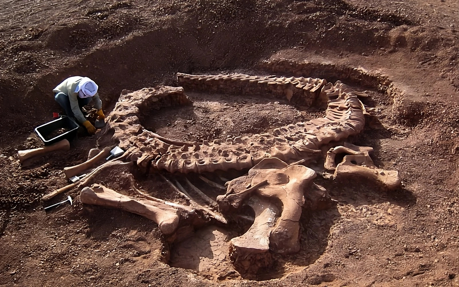
🦕 Tazoudasaurus: Witness to Geological History
Dinosaurs appear to have an ancient history in these mountains. The remains found in the Imghrane territory — specifically in the village of Tazouda in the Ait Zaghar region — attest to this.
The discovered fossils revealed that this dinosaur is the oldest among herbivorous four-legged dinosaurs, dating to the Lower Jurassic period.
Tazoudasaurus Specifications
- Length: Approximately 9.5 meters
- Scientific name: Tazoudasaurus Naimi
- Type: Herbivorous quadruped dinosaur
- Era: Lower Jurassic (approximately 180 million years ago)
📖 For more about this discovery, read our article: Tazoudasaurus: The Ancient Dragon of Imghrane
📍 The Precise Location of Imghrane
Imghrane is located primarily on the southern slope of the Central High Atlas, while its expansion reached the foothills of the northern side.
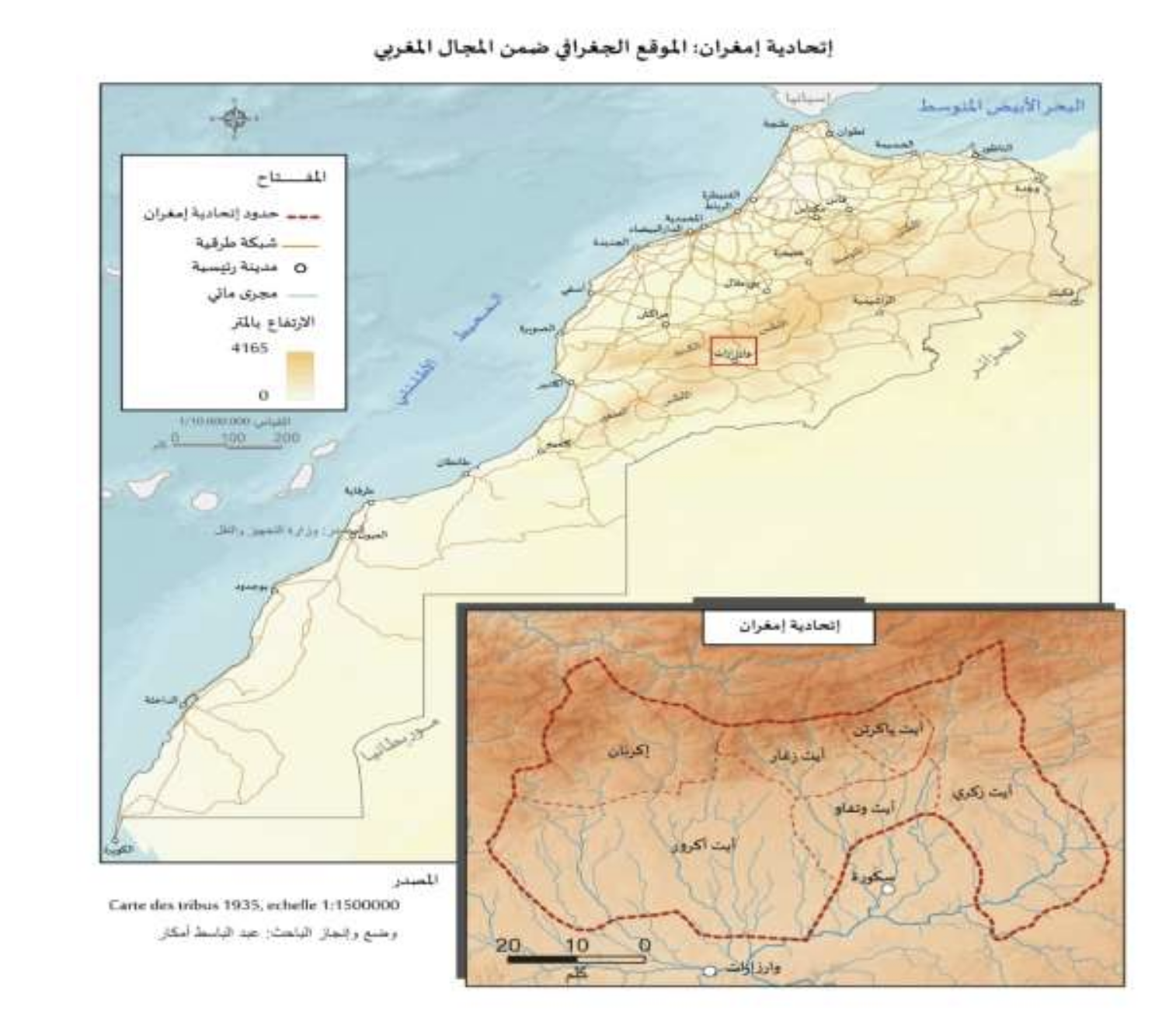
Geographic Boundaries
| Direction | Borders |
|---|---|
| North | Fetouaka |
| West | Southern Aglaou |
| South | Skoura (Oued Ouarzazate in the late 19th century) |
| East | Jebel Imgoun (4,071m) and the territories of the Imgoun and Ait Sedrate tribes extending to the Saghro tribal territories |
🛤️ Imghrane: A Strategic and Commercial Corridor
The Imghrane territory forms an important commercial and strategic corridor because of:
- Its link between interior and Saharan regions
- Its role as a connection point between well-known commercial centers:
- Demnate to the north
- Marrakech to the west
- Draa to the south
- Tafilalet to the east
🗣️ A Transitional Zone: Linguistically and Politically
The Imghrane territory is considered a transitional zone — geographically and historically — on several levels:
Linguistically
Imghrane sits at the dividing line between two Amazigh dialects:
- Tashelhit to the west
- Tamazight to the east
The confederation as a whole speaks Tashelhit, with the exception of some areas bordering the eastern frontier, such as the Ait Zekri, due to their proximity to the Ait Sedrate, Imgoun, and Ait Dades tribes.
Politically and Economically
| Orientation | Regions |
|---|---|
| Imghrane and Draa | Oriented toward Souss and Marrakech |
| Ferkla, Gheris, Ziz, and Guir | Oriented toward the north, Fez, and central Morocco |
| Todgha and Tazarine | Served as a link between both domains, influenced by both |
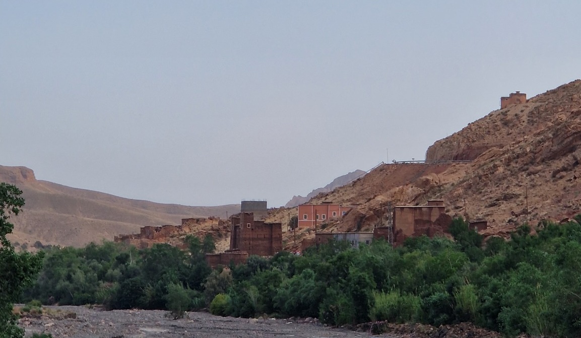
⛰️ Terrain
The Imghrane homeland is located between Tizi n’Kdit and Tizi n’Fdghat, overlooked to the east by Mount Imgoun (4,071m).
Terrain Characteristics
The region is characterized by predominantly mountainous terrain extending from Imi n’Oulaoune and Ghassat to the borders of Azilal:
- Major elevations: Ranging from 2,000 to 3,500m above sea level
- Tizi n’Oulaoune
- Jebel Tarkdit
- Rocky mountains: A strip extending below the limestone mass toward the east
- Plateaus and hills: Scattered across Azdal, Aseghmou, and other areas
- Plains: From the Ghassat area to the Toundoute area
📊 Summary of Geographic Characteristics
| Feature | Details |
|---|---|
| Location | Southern slope of the Central High Atlas |
| Elevation | 2,000 – 3,500m |
| Highest neighboring peak | Mount Imgoun (4,071m) |
| Predominant dialect | Tashelhit |
| Economic orientation | Souss, Marrakech, Draa |
| Terrain | Mountains, plateaus, plains |
| Key landmarks | Tizi n’Kdit, Tizi n’Fdghat, Imi n’Oulaoune |
🌿 Conclusion
This overview reveals that the geographic location of Imghrane was far more than a neutral natural setting — it was a decisive factor in shaping the region’s identity and history. Its position on the southern slope of the Central High Atlas — between mountain passes and plains — made it a strategic corridor linking Morocco’s major commercial centers.
Its deep geological history — attested by the Tazoudasaurus discovery — and the ecological richness of its mountains reveal a thriving environment that attracted human settlement since the most ancient times, as discussed in our previous article: Geography of Imghrane: Natural Setting and Ancient Human Settlement.
📚 Sources and References
Abdelbasset Amkar, Aspects of the History of the Imghrane Confederation During the 19th Century, Master’s thesis, Department of History and Civilization, supervised by Dr. Mustapha El Kadiri, Academic Year 2023–2024.
Key references cited in the research:
- Houzali (Ahmad), The High Atlas, Ma’lamat al-Maghrib, Vol. 2, Moroccan Association for Authorship, Translation and Publishing, Salé, 2005, p. 497.
- Oujamaa (Muhammad), Imghrane, Ma’lamat al-Maghrib, Vol. 3, p. 771.
- Meunié (J), Hiérarchie sociale au Maroc présaharien, Hespéris, 1st and 2nd quarters, 1958, p. 256.
- Imghri Blog: imghri.blogspot.com
This article is the third in a series on the history of the Imghrane confederation. Also read: